Is Infrastructure Tourism Just for Enthusiasts? — Utilizing Erosion Control Structures and Surrounding Landscapes as "Indexes That Tell the Story of Local History" —

The Policy Bureau of the Ministry of Land, Infrastructure, Transport and Tourism is actively promoting and revitalizing "infrastructure tourism" as part of its efforts to transform domestic infrastructure sites into tourist attractions. We examine this trend—which has traditionally been the domain of enthusiasts, encompassing industrial zones and dams—in light of the results of our own survey.
Rediscovering Giant Man-Made Structures as Tourist Attractions
Some of you may have heard the term “factory moe,” which emerged about ten years ago. It refers to the aesthetic appreciation of the imposing structural beauty found in the nighttime illumination of industrial complexes and factories, as well as their chimneys, pipes, and clusters of tanks. As this term spread through the internet and other channels, the market for factory appreciation as a hobby expanded, and numerous photo books featuring factory nightscapes were published. This movement differed in focus from industrial tourism—which involves touring and experiencing manufacturing processes inside factories—and was instead a movement dedicated to rediscovering the beauty of form and color.
In industrial areas and regions with industrial complexes, the emergence of previously unanticipated sites as new tourist attractions has led to the launch of guided tours. Kitakyushu City, home to the Kitakyushu Industrial Zone, began offering nightscape viewing bus tours in 2010. Even today, “regular nightscape viewing cruises” are operated, allowing visitors to admire the night views of coastal factories and the Kanmon Strait from aboard a ship. At the Fuji Chamber of Commerce and Industry, an organization called the “Fuji Factory Nightscape Club” organizes tours where participants photograph factory nightscapes under the guidance of professional photographers, a program that has proven popular even among women.
In the 1970s, after environmental pollution issues came to light, modern factories have evolved through improvements in safety, greening, and the creation of park-like spaces, and are no longer perceived by residents as a source of harm. Furthermore, as demand for industrial tourism and “adult field trips” has grown, and with the widespread use of digital cameras making it easy for anyone to capture beautiful nightscapes, factories have come to be reevaluated for their functional and structural beauty.
The Popularization of Infrastructure Tourism
This style of tourism, which began with factories and involves appreciating massive man-made structures, has expanded its scope. Dams, of course, enjoy unwavering popularity as a tourist resource. In addition to the publication of numerous photo books, awareness of “Dam Cards” has been growing year by year, and in 2014, a “Dam Manga” even appeared, featuring a high school girl who discovers the appeal of dams as its protagonist. Dams, which were once the object of desire for a select few enthusiasts—much like railways and anime—have now greatly expanded their fan base.
In May of this year, the Policy Bureau of the Ministry of Land, Infrastructure, Transport and Tourism launched the “Infrastructure Tourism Portal Site,” an information site for tours and hands-on experiences at infrastructure facilities such as dams and bridges across the country. As part of efforts to transform domestic infrastructure sites into tourist resources, the site aims to actively promote and revitalize infrastructure tourism. The infrastructure tours featured here include a total of 269 options (as of May 6, 2016, when the site launched), ranging from on-site tours hosted by facility managers to paid tours organized by travel agencies (privately hosted).The "Panel Corner" features a wealth of explanatory materials and highlights seasonal tours depending on the time of year. For example, the "Short Trip to Nagashima Dam via the Oigawa Railway" not only allows visitors to tour the interior of the dam but also introduces the fact that the Oigawa Railway operates retired private railway cars that have been refurbished. Links to the official websites are provided so that users can view details of each tour and make reservations.
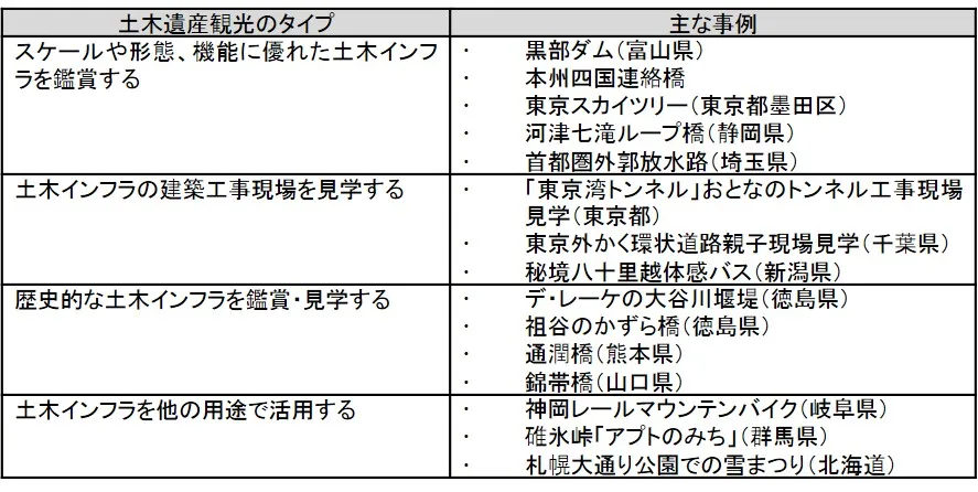
As can be seen from the tours and experiential programs listed on this portal site, while many of the featured examples involve dams used for power generation, the range of resources covered is diverse, including heritage sites related to flood control and agriculture, as well as roads. In reality, beyond what is listed on the portal site, a much broader range of civil engineering heritage serves as tourist attractions, and the purposes of visits vary widely depending on the specific site (Table 1).
Table 1: Types of Civil Engineering Heritage Tourism
Among these major civil engineering tourism attractions, erosion control facilities tend to fall into a somewhat minor category. The primary factors behind this are the inconvenience of their locations and the conditions of their maintenance during normal times. For hydroelectric dams, managers are stationed near the facilities, and safety can be ensured by restricting access to certain areas. It is often possible to tour the reservoir by sightseeing boat or rowboat, and development as a tourist destination is well underway. Furthermore, since bridges and roads are the access routes themselves, it is easy to reach them. On the other hand, erosion control facilities are often located in areas with poor ground conditions or deep in the mountains. Since they are rarely managed by permanent staff after construction, access routes are often undeveloped, and it is difficult to establish and maintain visitor areas that offer high levels of safety and comfort. Consequently, their conversion into tourism resources has been slow.
Examples of Erosion Control Facility Tourism
≪Otari Village: Doboku Art Erosion Control Dam Bus Tour≫
Otari Village in Nagano Prefecture, which suffered extensive damage from the 1911 (Meiji 44) Hieda Mountain landslide, is considered a landslide-prone area and is home to a wide variety of erosion control facilities—making it, so to speak, a mecca for such structures. It is said that the village’s old shrines and temples avoided damage by moving their buildings whenever ground movement was detected or landslides occurred nearby.
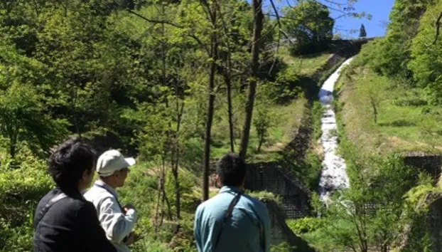
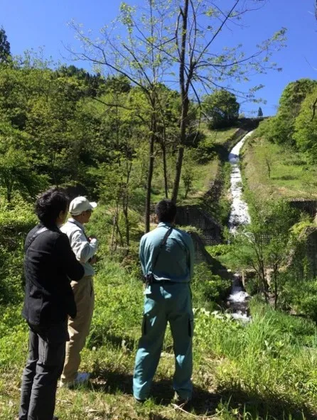
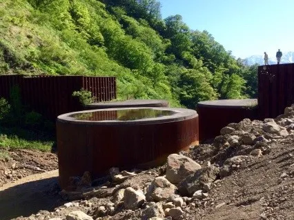
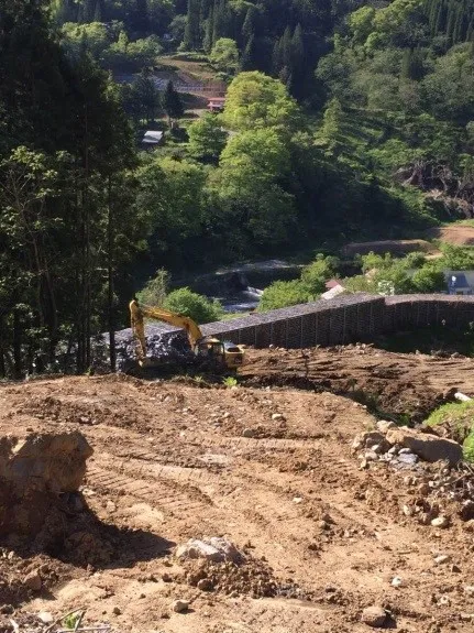
As a tourist destination, Otari Village has promoted its natural resources and winter sports attractions, such as its winter ski resorts and the skunk cabbage colonies at Tsugaike Nature Park. However, with the number of skiers declining year by year, it is difficult to expect a significant recovery in winter tourism demand. Furthermore, tourism demand that relies on the natural environment—such as wildflower blooms and autumn foliage—tends to be unstable. Against this backdrop, Otari Village developed the “Erosion Control Dam Tour” in 2013 as a destination-based tourism product (Photos 1, 2, 3). The village is cultivating this as a unique offering that cannot be replicated in other regions, designed to convey to visitors the nature of the land, the history of disaster prevention, and the progress and social significance of erosion control technology. The tours are held only during the summer, with approximately four sessions per year. Running from 9:00 a.m. to around 4:00 p.m., the itinerary is purpose-specific—excluding general sightseeing activities such as river channel works—and features detailed commentary by former prefectural employees who have been involved in sand control-related projects. Participants are primarily in their 20s and 30s, with a roughly equal male-to-female ratio. The high proportion of female participants came as a surprise even to the organizers.
Although the Otari Village Sand Control Dam Tour now enjoys quiet popularity and high acclaim, there were many challenges involved in bringing it to market. Simply establishing the infrastructure to ensure visitor safety—such as repairing roads damaged or severed by winter snow, managing summer weed growth, and arranging 4WD vehicles to transport visitors safely on unpaved roads—was a major undertaking. The framework for these infrastructure improvements was established through close collaboration between the city’s tourism department, national and prefectural erosion control offices, and local private-sector operators. Furthermore, the system for selecting and assigning interpreters capable of answering questions from civil engineering enthusiasts could not have been established without the cooperation of the national and prefectural erosion control offices. The organizers’ belief that “the importance and significance of public works can be conveyed precisely because Otari Village is home to a concentration of various types of erosion control facilities” was shared by the local erosion control offices, making it possible to realize this project as a cross-organizational collaborative effort.
≪Mima City “De Leke Oya River Erosion Control Weir”≫
There are numerous erosion control facilities in Japan left behind by Johannes de Rijke, one of the foreign experts invited to Japan during the Meiji period. Among them, the De Rijke Erosion Control Weir on the Oya River in Mima City, Tokushima Prefecture, is one of the largest. In 1994, the prefectural government began preservation and maintenance work on the dam itself, and it remains in active service today. The fact that this area was selected as a priority region to seek guidance from the “hired foreign experts”—a group of highly skilled professionals—suggests that measures for the Yoshino River basin were considered extremely important on a national scale.
Tokushima Prefecture has been known as a production area for Awa indigo since the Edo period. Indigo is prone to crop rotation problems, and since it is difficult to ensure a stable supply of high-quality indigo in standard fields, it held high value as an agricultural product. The Yoshino River basin, famous for its turbulent waters, was unsuitable for rice cultivation because it was prone to annual flooding. However, the fact that flooding renews the fertile soil provided ideal conditions for indigo cultivation, which requires frequent soil rotation. From the Edo period onward, until the decline of water transport on the Yoshino River, this area flourished as an indigo-producing region for a long time. Waki-machi, located near the De Rijke Erosion Control Dam, prospered as a distribution hub for Awa indigo transported by boat. The area, lined with merchant houses from that era, has been designated as an Important Group of Traditional Buildings known as the “Udatsu Townscape” and has become one of Tokushima Prefecture’s representative tourist destinations.
The area surrounding the De Lijke erosion control dam has been turned into a park, where tulips bloom profusely in the spring. When the water level of the Oya River is low, it is possible to walk up to the top of the dam and view up close the beautiful curves of the stone masonry, carved by the water flow over many years. Although a monument to De Lijke stands on the information board, unfortunately, the explanation regarding the dam itself is sparse, and the content focuses primarily on commemorating De Lijke himself. Although the area has been developed as a park, it is difficult for visitors to grasp the historical narrative as a coherent story—one that connects the characteristics of the Yoshino River, the history of local livelihoods that utilized those characteristics, the historical trends leading to erosion control measures for future generations to ensure safe living, and the resulting changes in the town’s structure. Such historical civil engineering heritage is often preserved in its original state or turned into a park with the aim of passing it on to future generations. Ideally, however, the development of the environment surrounding civil engineering heritage should not be carried out solely for the purpose of preservation. It is desirable that it be done to provide a visual trigger and tangible evidence that allows visitors to understand the nature of the region through the significance of these resources—viewed from various perspectives such as civil engineering, history, and tourism—and to foster a sense of pride in the land among residents.
The Reality of Civil Engineering Tourism and Its Target Audience
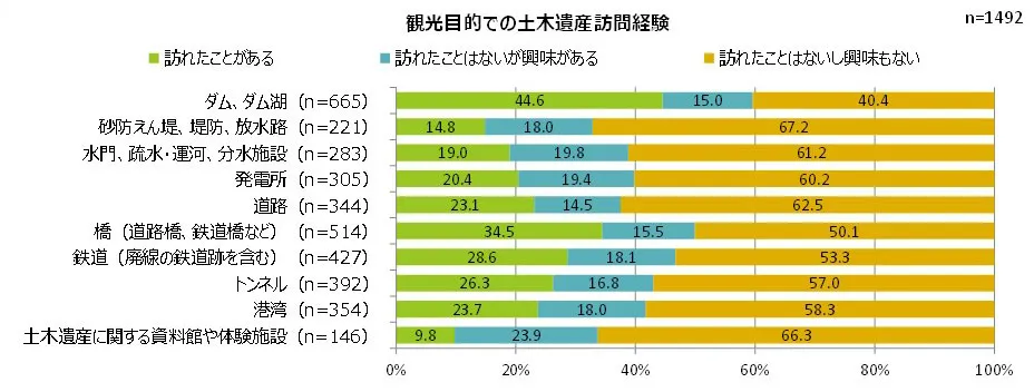
What types of civil engineering heritage sites are consumers actually visiting? According to a survey conducted by our company in May of this year, 44.6% of respondents—nearly half—have visited [dams and reservoir lakes] in the past, followed by [bridges] at 34.5%. Visits to [erosion control dams, levees, and spillways] remain low at around 15% (Figure 1).
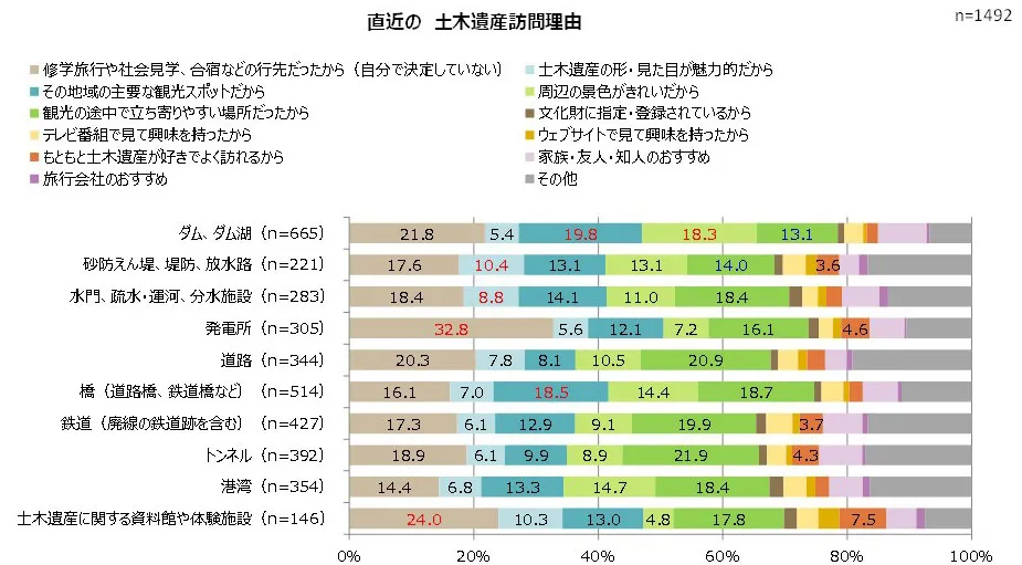
Regarding the main reasons for visiting these sites, for [dams and reservoir lakes], the percentages for “a major tourist attraction in the region” and “beautiful surrounding scenery” were both just under 20%, indicating that the utilization of dams and their surrounding landscapes as general regional tourist resources is being promoted (Figure 2).For [power plants] and [museums and hands-on facilities], the proportion of visits for “school trips, field trips, and training camps” is high. This suggests they are viewed as educational destinations due to their close relevance to everyday life for everyone and the growing importance of environmental and energy education. Regarding [Erosion Control Dams, Levees, and Outfall Channels], the percentage of respondents citing “the shape and appearance of civil engineering heritage are attractive” was the highest compared to other resources, suggesting that “connoisseurs” and “enthusiasts” who appreciate the functional beauty of the erosion control facilities themselves are likely visiting. Notably, for all resources, the percentage of people who stated, “I am already a fan of civil engineering heritage and visit often,” was less than 10%.
(Figure 1)
(Figure 2)
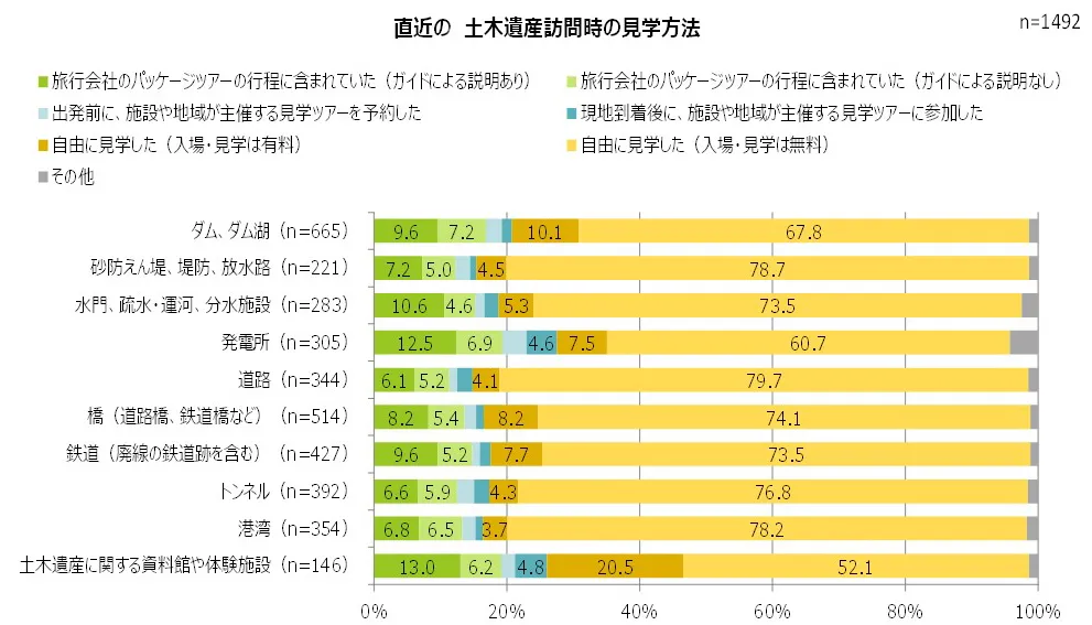
Regarding methods of visiting, “self-guided tours” accounted for the majority. “Included in a travel agency tour itinerary (with a guide’s explanation)” was the most common at around 10%, and this trend was particularly strong for facilities that are constantly staffed, such as [power plants] and [museums and hands-on facilities] (Figure 3). The percentage of visitors who “joined a guided tour organized by the facility or local community after arriving on-site” was low, suggesting that many visitors decide to visit before departure. Several factors may contribute to this, including fixed tour departure times, the requirement for reservations, and the fact that tours are not held frequently in the first place. While staffed facilities such as dams, museums, and power plants function as “marketable” tourism content, it can be concluded that tourism content centered on viewing disaster prevention infrastructure (such as erosion control facilities) and transportation infrastructure (such as roads and ports) has not yet reached a stage where it is viable as a business.
(Figure 3)
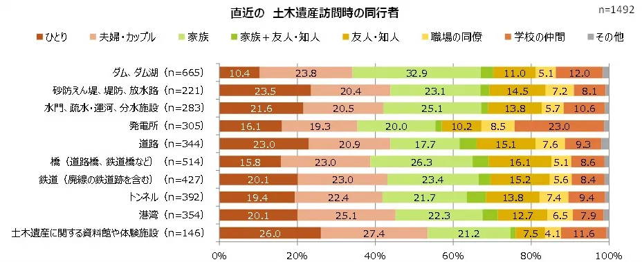
Regarding companions during the most recent visit, excluding [museums and hands-on facilities], the “solo” ratio was high for [landslide control dams, levees, and spillways], accounting for 23.5%. The “couples” ratio was high for [ports] at 25.1% and [dams and reservoir lakes] at 23.8%.Locations that allow visitors to enjoy the surrounding natural scenery and night views, as well as those equipped with ancillary facilities such as boat rides, activities, and dining options, are particularly popular. The highest proportion of “families” was found at [Dams and Reservoirs] (32.9%), followed by [Bridges] (26.3%) and [Sluices, Canal Channels, Canals, and Water Diversion Facilities] (25.1%) (Figure 4).
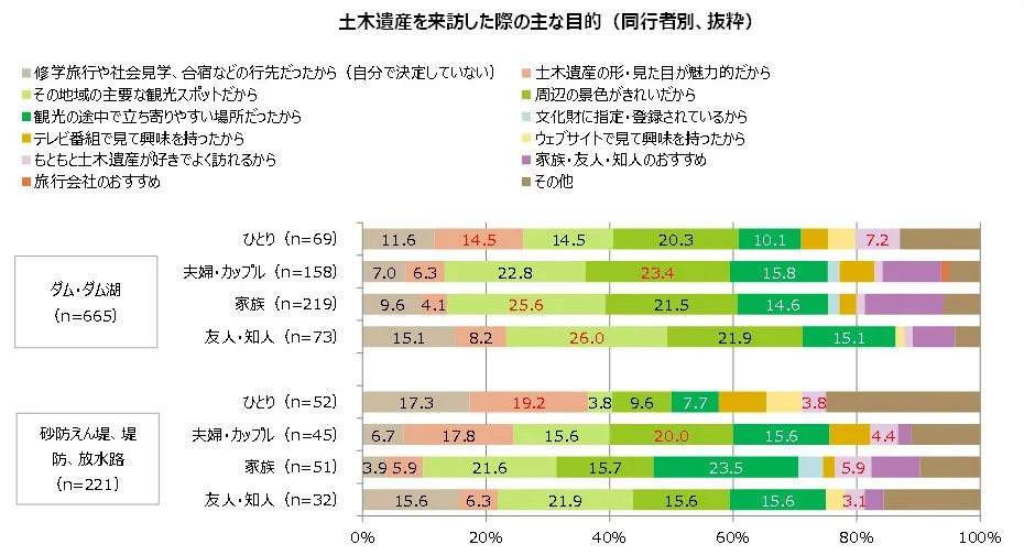
We compared the purposes of visit by travel companion for [Dams and Dam Lakes], where the utilization of tourism resources is advancing, and [Erosion Control Dams, Levees, and Spillways], which tend to impose inconveniences on visitors due to their location or viewing environment (Figure 5).In both cases, a high percentage of solo visitors cited “the shape and appearance of the civil engineering heritage are attractive,” and this trend is particularly strong for [Erosion control dams, levees, and spillways]. Additionally, a high percentage of “couples” cited “the surrounding scenery is beautiful,” suggesting they may find value in the harmony between man-made and natural landscapes. It appears that both “solo visitors” and “couples” actively decide to visit civil engineering heritage sites despite having diverse purposes, and a relatively large number of them are motivated by information gathered through media such as “saw it on TV” or “saw it on a website.” On the other hand, for families and friends/acquaintances, the purposes tend to be less specific, such as “it is a major tourist spot in the area” or “it was easy to stop by while sightseeing.”
Currently, regarding structures such as erosion control dams, there is a strong tendency for so-called “enthusiasts” to visit to appreciate their structural beauty. Those with clear objectives are more likely to visit as “solo travelers” or as “couples” who are close to one another. Furthermore, for “couples,” the ability to enjoy the surrounding scenery and location is also an important motivating factor. On the other hand, civil engineering heritage sites with historical value have low appeal, and it is evident that whether or not they are designated or registered as cultural properties has little impact on the desire to visit.
(Figure 4)
(Figure 5)
What is Sought is a “Narrative” Rooted in the Land
The concept of value in civil engineering heritage is often expressed by the terms “Function, Strength, and Beauty.”“Utility” refers to the excellence of function, technology, and scale; “Strength” encompasses disaster resilience, durability, and the excellence of management systems; and “Beauty” encompasses not only the beauty of the structure’s form, construction, and materials but also the uniqueness of the landscape in harmony with the surrounding environment. Furthermore, it is clear that the current market for civil engineering tourism, which is driven by a specific purpose, cites “Beauty” as the primary motivation for visiting.
The values of “Utility, Strength, and Beauty” inherent in civil engineering heritage are brought to the public’s attention through the completed facilities located in each region. What local communities wish to convey to visitors through civil engineering tourism extends beyond the visual aspects of “Utility, Strength, and Beauty” of these structures; it includes the history of the struggle between natural disasters and the livelihoods of the people living there, as well as the historical context that led to the creation of these structures.
The Metropolitan Area Outer Floodway (managed by the Edogawa River Office), known as the “Underground Temple” and receiving increasing media attention in recent years, is one of the world’s largest underground floodways. It is open to the public, and special tours are also held. Visitors learn about the facility’s grand scale through the media, are genuinely impressed by the space’s cool aesthetic, and want to stand there themselves. They apply for a tour with the expectation of visiting a special, hard-to-reach location (and having something to brag about to others). They are then surprised by the depth and cold of the underground space, take beautiful photos of the illuminated area and feel satisfied, and marvel at the explanations of the facility’s structure and significance. However, this alone is insufficient to convey the stories of the land or the facility’s deeper value. The “Tone River Eastward Diversion Project” began in the Edo period. A wide range of urban development initiatives in Edo and its surrounding areas—including soil improvement, new rice field development, urban planning, waterway development, crisis management, and disaster prevention—have continued uninterrupted from the time of Tokugawa Ieyasu to the present day, leading directly to the current Outer Bypass Channel. The livelihoods of people who have lived in harmony with nature have evolved; subsequently, as disaster countermeasures were strengthened, the lives and livelihoods of local residents—deeply intertwined with infrastructure development—have changed. Behind this evolution lay political and economic contexts and strategies in which disaster prevention projects were indispensable. Furthermore, the development and maintenance of infrastructure involve the history of the hardships endured by those involved and the progress of technology, and even now, new technologies are being created daily for the future.
When it comes to erosion control facilities, they possess a grand yet unassuming nature: situated deep in the mountains or at their foothills, they ward off natural threats that occur perhaps once every few hundred years, while being expected to eventually blend in and become one with nature in the distant future. There is a dilemma here: if, like a hydroelectric dam, the control buildings and surrounding environment were perfectly maintained, it would actually distance the facility from the very essence of its existence. To fully appreciate active erosion control facilities as tourist attractions, it is essential to provide accurate and concise interpretation regarding the history and necessity of the battle against erosion in that region, the functional reasons behind the structural beauty of the facilities, and the significance of their location. However, to ensure that visitors properly commit both the visual impact of the facilities and the content of the interpretation to memory, the setting should not be overly staged. I hope that by using “Function, Strength, and Beauty” as a starting point for understanding, and by presenting the stories of reverence for nature and the local community through various landscapes and environments—changing the time of day from day to night and across the seasons—visitors will be able to sense a fleeting moment within the long span of time that the erosion control project encompasses, from the past to the future. When viewed through eyes that understand this context, a landscape where natural scenery and civil engineering structures harmonize evokes emotions that go beyond mere comments like “That’s pretty” or “That’s cool.” At that moment, civil engineering heritage can transcend the label of being merely a “tourist resource for a niche group of civil engineering enthusiasts.”
When building such thoughtful content, it is essential to first go through a process of sharing a vision within the community regarding what kind of value civil engineering tourism aims to create for society and the region itself. It is crucial to establish a policy—whether to operate civil engineering tourism as a business or to promote it as a community initiative aimed at social benefits such as public awareness—and to ensure that this understanding is shared among local governments and relevant businesses. Tourism content that conveys value through thoughtful interpretation involves increased costs related to facility development, guide training, and staffing. If the goal is to establish it as a viable business, it can be refined as a flagship attraction for “corporate field trips” organized by companies and other groups. This can be packaged as a high-value-added experience that includes elaborate local cuisine and comfortable accommodations, or it can be developed as a specialized plan for high-value customers belonging to corporate membership organizations. If you wish to prioritize social impact and educational value even at the expense of costs, it is important to raise public awareness of the site’s significance through symposia and outreach events in collaboration with local museums and civil engineering heritage sites in other regions. At the same time, to allow visitors who have come to the area for other purposes to casually experience the civil engineering heritage, it is crucial to broaden access by increasing the number of information points and guides, as well as offering a variety of itineraries tailored to the time available.
That said, as a self-proclaimed enthusiast (albeit a minor one), I must confess that I secretly hope the “frozen beauty deep within nature” of these erosion control dams will remain quietly preserved, unknown to most people.
"Survey on Civil Engineering Heritage" Overview
Survey Participants: A total of 1
,500 men and women aged
20–69 residing in the Tokyo Metropolitan Area (Saitama, Chiba, Tokyo, Kanagawa), the Chukyo-Tokai Region (Gifu, Shizuoka, Aichi, Mie), and the Kansai Region (Shiga, Kyoto, Osaka, Hyogo, Nara, Wakayama) Survey Period: May 16 (Mon) – 18 (Wed),
2016 Survey Cooperation: Bulk Co., Ltd.
*This article is a reprint of a contribution to “sabo” (Vol. 120, Summer 2016), published by the Public Interest Incorporated Foundation Sabo and Landslide Technology Center.
著者