Why a "Map of People Flow" Is Essential for a Tourism-Oriented Nation: Bridging the Value of the 5th Basic Plan for Promoting a Tourism-Oriented Nation to "Local Realities"

With 42.68 million international visitors and 9.5 trillion yen in spending, Japan’s tourism industry is riding a wave of unprecedented momentum. However, attracting visitors to regional areas remains a structural challenge. Now that the Fifth Basic Plan for Promoting Japan as a Tourism-Oriented Nation has been approved by the Cabinet, the focus shifts to how to design and implement this plan. In this column, I propose the concept of a “map of visitor flows” and reexamine the effectiveness of Japan’s strategy to become a tourism-oriented nation.
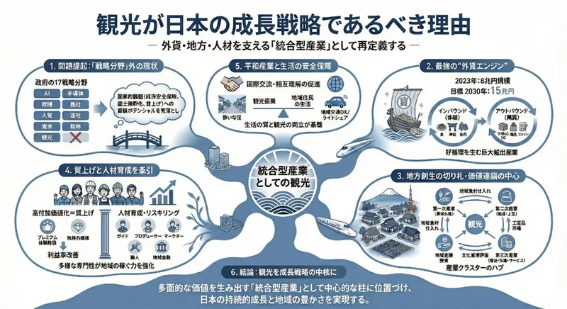
Tourism is an “integrated industry” that drives Japan
On March 27, 2026, the "5th Basic Plan for Promoting Japan as a Tourism-Oriented Nation," which will serve as the new compass for Japan’s tourism policy, was approved by the Cabinet. To fully grasp the significance of this plan, I would first like to redefine the essence of "tourism"—the very activity upon which we must base our efforts.
Tourism is not merely a form of leisure or a segment of the service industry. It generates foreign exchange through visits by international tourists, accelerates regional revitalization through the circulation of consumption, achieves wage increases by enhancing service value, and increases the number of Japan’s fans worldwide through grassroots international exchange. It is an “integrated industry” with the potential to simultaneously and synergistically resolve the most critical challenges facing modern Japan.
How can we position this multifunctional and powerful industry as the true protagonist of the nation’s growth strategy and ensure its benefits reach every corner of the country? To ensure that the ambitious goals set forth in the Fifth Basic Plan do not end as mere numerical targets, but are transformed into “tangible results” that allow regions to truly experience prosperity, there is a concept we must discuss now. That is the “Map of People Flow” proposed in this article.
Structural Challenges Behind the Boom
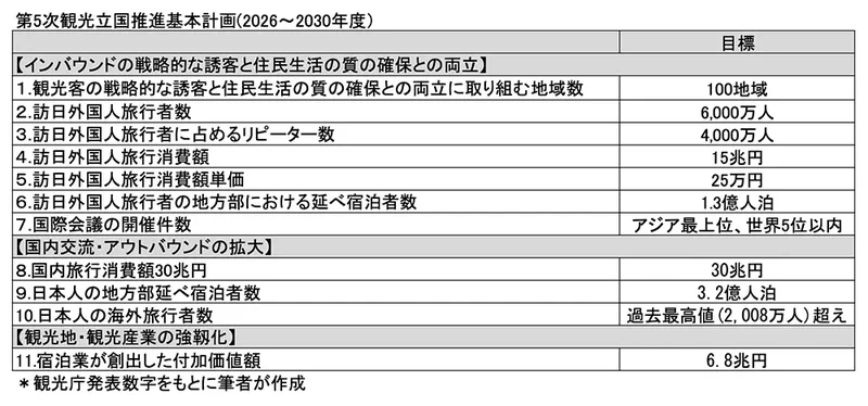
Japan’s tourism industry is currently riding an unprecedented wave of momentum.In 2025, the total number of overnight stays by foreign visitors reached a record high of 177.87 million. The Fifth Plan aims for even greater heights by 2030: 60 million international visitors and 15 trillion yen in tourism spending. The clear articulation of “quality goals”—such as harmonizing tourism with local residents’ lives and enhancing the value added by the accommodation industry—represents a significant evolution in policy.
However, behind these impressive figures, we continue to face structural challenges. The proportion of international visitors staying in the three major metropolitan areas rose from 62.7% in 2019 to 72.1% in 2023. Even in the final figures for 2024, this proportion remained high at approximately 69%.Although the number of overnight stays in regional areas began to show signs of dispersion in 2025, with monthly year-on-year growth of 10–15%, the concentration in the three major metropolitan areas continues in terms of overall share.
For more than a decade, the national government has made “attracting visitors to regional areas” a top priority, investing enormous energy through public-private partnerships in initiatives such as fostering DMOs and certifying wide-area touring routes. Despite this, why has the concentration in urban areas not fully returned to pre-pandemic levels?
I do not believe the measures were insufficient. The issue lies not in the quantity of measures, but in the perspective of how they are designed. Looking at the planning process, the structure involves various ministries and local governments piling up measures, which are then bundled together at the end.While travelers’ routes cross prefectural borders and ministerial jurisdictions, plans are created within those boundaries. Furthermore, the “results” of regional tourism promotion are measured by the accumulation of metrics such as the number of overnight stays and total spending, with no consideration given to changes in travel patterns—specifically, “how travelers arrived there.” While the appeal of individual “points” has increased, the “overall design” of how travelers move across the Japanese landscape remains incomplete.
“A Map of People Flow” — A Blueprint Connecting Policies with Lines
The 5th Plan incorporates a wide variety of concrete measures aimed at enhancing tourist destinations, strengthening information dissemination, and improving the environment for welcoming travelers. Each of these individual measures is an extremely important tool for the regions. The next step we must take now is to connect these excellent measures with “lines” and visualize them as traveler routes. That is the “Map of People Flow.”
Why do people flock to the Golden Route (Tokyo–Mt. Fuji–Kyoto–Osaka)? The reason lies in the fact that transportation infrastructure, information density, and lodging options are relatively well-established along this route, making it an easy choice for travelers. In today’s Japan, this route functions as a rational and comfortable option due to its structural advantages.
If we maintain this structure as a given, it will be difficult for individual regions to change the overall flow simply by refining their own content. What is needed is not just for the government to present a menu of “what it will support,” but also to draw up a blueprint that embodies a spatial vision: “how travelers can move,” and “what new flows the government wishes to create.”
A “map of policies” is a map that outlines what the government will do.
A “map of people flow” is a map that details where and why travelers are directed.
Promoting tourism as an integrated industry is the very process of drawing this “map of people flow” and, based on it, aligning with other policies such as transportation, industry, and living infrastructure.
"Intentional Design" by Nations: A Global Perspective
If we look at countries that are leaders in tourism, we can see how conscious they are of the structural design of their “maps of human flow.”
France—Designing People Flow Routes Through Railways and Regulations
In 2021, France announced the “Destination France” plan at a summit presided over by President Macron himself. The core of this 10-year, 1.9 billion euro (approximately 300 billion yen) plan lies in a regionally decentralized structural design centered on a 28,000-kilometer railway network.In 2023, France enacted a law mandating rail alternatives for domestic routes meeting certain criteria, initially implementing this on three routes departing from Paris-Orly. What is significant is that France is treating the pathways of human movement themselves as a design target—not merely through environmental considerations, subsidies, or incentives, but through transportation systems and institutional frameworks.
Spain—Prime Minister “Declares” a €3.4 Billion Investment
In Spain, the Prime Minister himself positioned tourism as a cornerstone of the nation and publicly announced a package of investments exceeding 3.4 billion euros, utilizing the EU Recovery Fund. By stating that “tourism is an engine of transformation” and outlining the funding sources, tourism policy has been elevated from mere industrial support to a structural reform of the entire nation. What is significant is that the nation’s top leader has declared tourism to be a “design objective” and publicly committed to the necessary funding.
New Zealand—Codifying “a more deliberate and active role for government”
New Zealand’s government tourism strategy places “a more deliberate and active role for government in tourism” at the center of its approach.This is a declaration of intent that the government will not merely follow market trends but will “deliberately” intervene to design a framework in which tourism has a positive impact on the environment and society. The Tourism Growth Roadmap outlines a phased scenario shifting from short-term marketing investments to mid-term infrastructure and human resource development, and this timeline-based design—specifying “when to invest in what”—serves as a concrete manifestation of national will.
A “National Self-Definition” Common to All Three Countries—and Japan’s Structural Constraints
What these three countries have in common is that the state is redefining itself from a “facilitator” to a “creator.” When compared with the verbs used in Japan’s plan—“promote, support, and facilitate”—the difference in design philosophy becomes even clearer.
So why is this shift difficult to achieve in Japan? One factor lies in the structure of funding sources. Japan’s International Tourism Tax (approximately 55 billion yen annually), a valuable source of revenue, is largely dispersed as subsidies for individual initiatives.While France and Spain make large-scale, concentrated investments in tourism infrastructure through their national budgets, Japan’s structure does not allow funding to support a national policy of “concentrating investment here.” Inevitably, the focus shifts from “design” to “distribution.” The difficulty in mapping out tourist flows stems from the absence of a grand design that would institutionally justify concentrated investment of financial resources.
The Blueprint for a Tourism-Oriented Nation Embedded in National Land Policy
The blueprint for mapping tourist flows actually exists within Japan’s national land policy. This is embodied in the “National Land Grand Design 2050: Formation of a Land Promoting Circulation,” formulated by the Ministry of Land, Infrastructure, Transport and Tourism in 2014.The materials for this design were already in place: the four national axes—“the Northeast National Axis, the Sea of Japan National Axis, the Pacific New National Axis, and the Western Japan National Axis”—which Japan’s national land policy has upheld since 1998; “5,000 small hubs” (which, in a tourism context, overlap with regional stay hubs where travelers actually stay and experience the unique local culture); and the explicit strategic goal of “realizing a tourism-oriented nation that showcases the nation’s splendor.”
However, while this grand design was carried over into the National Land Formation Plan, it cannot yet be said to be fully reflected in the Basic Plan for Promoting a Tourism-Oriented Nation. Even within the same Ministry of Land, Infrastructure, Transport and Tourism, there exist two distinct axes: the Land Policy Bureau, which is responsible for the spatial design of the national territory, and the Japan Tourism Agency, which promotes tourism policies. Judging from the plan documents, the insights of these two bodies have not been integrated toward the common goal of designing tourist flow patterns.
Just as the National Land Formation Plan spatially expresses the national will to “build a Shinkansen line here,” the Basic Plan for Promoting a Tourism-Oriented Nation should also possess a spatial will to “create tourist flows along this axis.” If this has not yet been realized, does it not suggest that there is still room to incorporate the perspective that “the state is the primary agent in creating tourist flows” more deeply into the plan’s design philosophy?Filling this gap is the first step in mapping tourist flows.
The Three Layers Shaping the “Map of People Flow”
1. Rebuilding the Three-Layer Network of Tourism Hubs
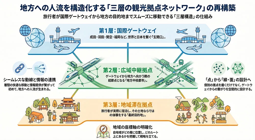
Travelers’ routes naturally follow three layers. The first layer consists of “international gateways” (Narita, Haneda, Kansai, Fukuoka, etc.); the second layer comprises “wide-area transit hubs” (regional core cities that serve as nodes when traveling from gateways to the countryside); and the third layer consists of “regional stay hubs” (destinations where travelers actually stay and experience what is unique to that area).
Current initiatives, such as the development of high-value-added model tourist destinations, are moving in the right direction by enhancing the appeal of the third tier. However, what is crucial is the comfort of the travel routes and the connectivity of information as travelers move “from the first tier to the second, and from the second to the third.” Only when these three tiers are designed as a network that seamlessly connects will the flow of people to regional areas become structured.
2. Synchronizing “National Axis” and “Tourist Flow”
We will explicitly overlay the design of tourist flows onto the four national axes established by Japan’s land use policy over many years.By identifying “current flow patterns,” “target flow patterns,” and “key hubs to be developed” for each axis, priorities for transportation, lodging, and stakeholder development will be determined based on spatial logic. Synchronizing “hard” investments—such as Shinkansen extensions and highway networks—with “soft” investments—such as promotion and DMO support—along the same axis will maximize the synergistic effects of these investments.
3. “Dynamic Scenarios” Incorporating Change
A map is not something that is drawn once and then forgotten. Major infrastructure changes—such as the opening of the Chuo Linear Shinkansen, the extension of the Hokuriku Shinkansen, and the extension of the Hokkaido Shinkansen to Sapporo—will occur over the next 10 to 20 years. These developments have the potential to structurally transform tourist flows in Japan. By presenting phased scenarios that account for these changes, the government will enable private-sector operators to confidently make long-term investments in accommodation facilities and tourism content. A map of tourist flows must not be a static blueprint, but rather a scenario that incorporates a timeline.
Toward a “Co-creation” Platform Beyond Administrative Boundaries
The mechanisms for implementing the “map of tourist flows” actually already exist. A cross-ministerial promotion framework, led by the Cabinet Council for Promoting Japan as a Tourism Nation, has already been established, and the Fifth National Tourism Plan explicitly identified “strengthening collaboration between tourism, transportation, and urban development” as a new policy direction. This is an important step.
However, I would like to raise one question. The discussions in these forums primarily focus on “what to do (policies).” It seems to me that “in which regions, along which axes, and what kind of people flows to create (spatial design)” has not yet become a central agenda item.
Within the existing framework for collaboration, we must establish a forum to discuss the National Land Formation Plan’s wide-area regional plans and the Basic Plan for Promoting a Tourism-Oriented Nation based on a single blueprint.While collaborating with the Ministry of Agriculture, Forestry and Fisheries, the Ministry of Education, Culture, Sports, Science and Technology (Agency for Cultural Affairs), and the Ministry of the Environment, we must directly address the agenda of “which national resources to concentrate on which hubs along which axes, and when.” This does not mean creating a new organization, but rather deepening the agenda of existing meetings. The “map of people flows” should emerge from these discussions.
Local communities are the “main characters” of the map
The “Map of Human Flow” is built on two pillars: the national government holding the blueprint and local communities establishing their own coordinates.
Only when the national government has a blueprint for “generating people flow along this axis” can local communities begin to ask, “Where do we fit into that blueprint?”When DMOs and tourism operators ask, “Where does our region fit within the three tiers?” “On which national axis do we lie?” and “Where do current travelers come from and where are they headed?”—this signifies a shift from a vague approach of “we just want anyone to come” to a high-resolution strategy focused on “connecting the specific demographic arriving via this gateway and passing through this hub to the best possible experience in our region.”
Only by possessing these coordinates can we clearly see what infrastructure to develop, which markets to target, and which neighboring regions to collaborate with. When the national government’s overarching vision overlaps with the bottom-up planning built by local communities, the initiatives of the Fifth National Tourism Plan will transform into a powerful engine that brings genuine prosperity to the regions.
“Mapping the flow of people” is not the sole responsibility of the national government, nor is it the sole responsibility of local communities. When the national government has a clear vision and local communities have a clear direction—that collaboration creates a structure that naturally draws travelers deeper into the heart of Japan.
In Conclusion—Who Will Draw That Map?
The “map of human flow” is not a map that predicts where travelers will go. It is a map in which the nation declares where it will create human flow.
The 5th Basic Plan for Promoting Japan as a Tourism-Oriented Nation is an ambitious plan that positions tourism as a “strategic industry.” Its direction is correct, and its quality and scope are worthy of praise. That is precisely why I must ask: Is the “map” that drives this strategic industry included in this plan?
Tourism supports Japan’s pride, generates vitality in regional areas, and serves as a bridge to the world. Such a future begins not with the accumulation of policies, but with the design of human flow. Who will draw that map, when, and how? The announcement of the 5th Plan is the best opportunity to confront that question.
著者